Executive White Paper / 2026
Landslide Risk · Earth Observation · AI
From Landslide Maps to Landslide Intelligence
How GIS, Earth observation and AI are changing local government risk management.
An executive white paper for U.S. local government—for GIS leaders, public works, engineering, planning, emergency management, resilience, IT/data leadership and city/county executives.
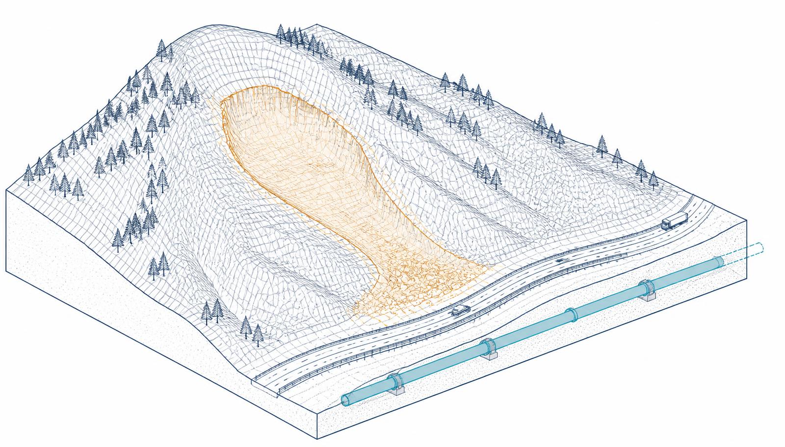
Executive Brief
The map is no longer the end product
For decades, landslide susceptibility mapping has largely answered one question: where is the terrain most likely to fail? That question remains important. But the technology surrounding it is changing quickly.
A major 2026 review of global landslide susceptibility research examined more than 2,000 scientific articles published between 2015 and 2025. It found a clear shift away from relying primarily on conventional GIS-based susceptibility mapping toward a much more integrated environment combining GIS, remote sensing, machine learning, Earth observation, cloud computing and artificial intelligence. The researchers describe this emerging environment as Geospatial-AI infrastructure.
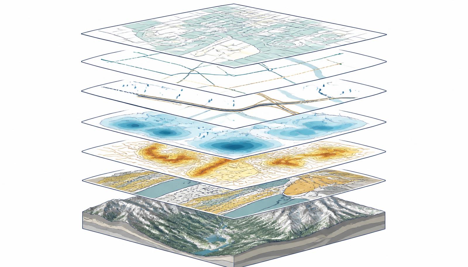
For local government, this is more than an academic trend. It points toward a different way of managing risk. Instead of producing a map every few years showing areas of high, medium and low susceptibility, agencies can increasingly bring together terrain and geology; rainfall and environmental conditions; LiDAR; satellite observations; UAV imagery; surface-deformation measurements; land-use change; historical incidents; roads and bridges; utilities and public facilities; parcels and development; and predictive analytics.
The result is not simply a better landslide map. It is the foundation of a spatial decision system.
The opportunity is to move from knowing where a hazard exists to understanding where changing conditions could affect the assets, infrastructure and communities that matter most. The significance for local government is straightforward: GIS is moving from describing risk to helping agencies prioritize what to investigate, protect and monitor.
Section 1
Why Local Government Should Care
A landslide is rarely just a geological event. It can quickly become:
- A transportation problem when a road closes.
- A utility problem when water, sewer, power or communications infrastructure is damaged.
- An emergency-management problem when access or evacuation routes are compromised.
- A planning problem when development occurs in vulnerable terrain.
- A capital-planning problem when mitigation competes with other infrastructure investments.
- And ultimately a public-safety problem when people and property are exposed.
Landslide susceptibility is influenced by a combination of geology, slope, rainfall, soil saturation and seismic conditions, along with human activities including land-use change and infrastructure development. That makes landslide risk inherently cross-departmental.
The most useful question may no longer be
Do we have a landslide susceptibility map?
A better question is
Can our organization connect slope risk to infrastructure, development, operations and emergency decisions?
Section 2
The Technology Shift: From Static Susceptibility to Dynamic Spatial Intelligence
The underlying research shows how rapidly this field is changing. Scientific activity around geospatial landslide susceptibility increased substantially during the last decade, particularly after 2019. Behind that growth is the convergence of several technologies that previously operated much more independently.
01
GIS
The organizing environment. It combines terrain, geology, parcels, infrastructure, roads, land use, hazards and operational information—increasingly doing more than displaying a final landslide layer. GIS becomes the place where information from multiple systems is brought together and interpreted in context.
02
LiDAR
Exceptionally detailed elevation and terrain information, revealing subtle slope features and drainage patterns difficult to see in conventional aerial imagery. Repeat acquisition also allows comparison of how landscapes change over time.
03
InSAR
Interferometric Synthetic Aperture Radar can measure very small changes in the Earth's surface—so agencies may identify locations where the ground itself appears to be moving, not only where landslides occurred previously. It is specialized and requires expert interpretation.
04
UAVs
Drones provide extremely detailed imagery and terrain information over targeted locations. Their value is usually not replacing jurisdiction-wide remote sensing, but supplying far more detail at priority sites.
05
Satellite Earth Observation
Satellite imagery brings time. Repeated observations help agencies understand not only what a location looks like, but whether environmental conditions are changing.
06
Cloud Computing
Cloud-based platforms increasingly allow analysts to work with huge Earth-observation datasets without downloading and maintaining everything locally.
07
Artificial Intelligence
Machine learning can analyze relationships among large numbers of environmental and spatial variables, identifying patterns associated with previous failures and where similar combinations of conditions exist elsewhere.
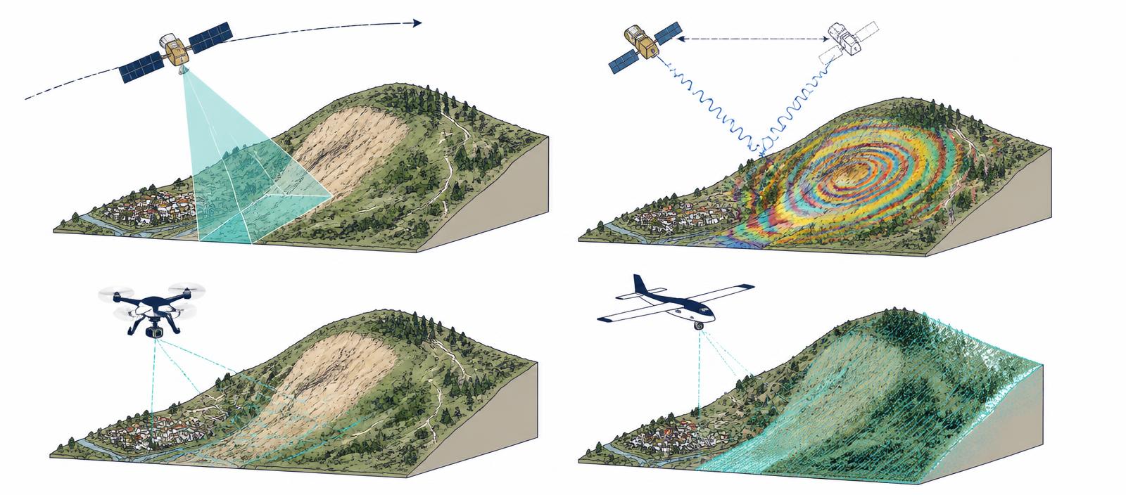
Diagram 1 — From Map to Intelligence
Traditional Approach
- Terrain + Geology + Historic Landslides
- GIS Analysis
- Susceptibility Map
Emerging Approach
- Terrain + Earth Observation + Rainfall + Land Use + Infrastructure + History
- GIS + Cloud Processing + Analytics + AI
- Changing Risk + Exposure + Consequence
- Inspection • Planning • Mitigation • Emergency Decisions
AI does not replace GIS. It expands what GIS can help government understand.
Section 3
From Hazard to Consequence: A Better Map Is Useful, a Better Decision Is More Valuable
Local government ultimately cares about consequences. A highly susceptible slope in an isolated area may require monitoring. A similar slope immediately above a major highway, water-treatment facility or residential neighborhood has an entirely different significance.
That is where GIS becomes especially powerful. It allows agencies to combine the physical hazard with what sits above, below and around it. A GIS-based risk environment can potentially answer questions such as:
- Is there a road below the slope?
- Is that road an evacuation route?
- Is a major water line nearby?
- Are homes potentially exposed?
- Is development planned in the area?
- Has movement occurred previously?
- Are drainage problems documented?
- Is the area recently affected by wildfire?
- Are there critical communications assets nearby?
- Would failure isolate a community?
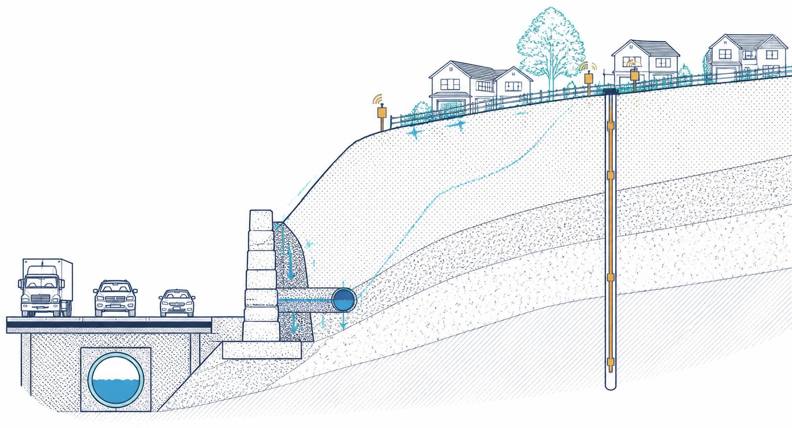
Diagram 2 — The Local-Government Risk Chain
Hazard to Action
- HAZARD — Where is terrain susceptible?
- EXPOSURE — What people, assets and infrastructure are present?
- CONSEQUENCE — What happens if failure occurs?
- PRIORITY — Where should government focus first?
- ACTION — Inspect • Engineer • Maintain • Mitigate • Plan • Prepare
The progression from hazard to consequence is where landslide mapping becomes a local-government management tool.
Section 4
What Each Department Asks
01
Public Works
Which unstable slopes threaten roads; which routes lack practical alternatives; where drainage problems are increasing slope vulnerability; where culverts or retaining structures require attention; and which sites should be inspected before major storm events.
02
Engineering
Which locations warrant geotechnical investigation; where movement has been detected; which mitigation projects protect the greatest infrastructure value; and where monitoring equipment should be installed.
03
Planning
Which proposed developments intersect vulnerable terrain; where additional geotechnical investigation should be required; whether hillside-development standards should change; and how susceptibility should influence long-range planning.
04
Emergency Management
Which neighborhoods could become isolated; whether evacuation routes are exposed; which critical facilities are vulnerable; and where landslides could create cascading hazards such as debris flows or flooding.
GIS becomes the common spatial language connecting all of those questions.
What this means for your city/county
Imagine clicking a high-risk location and immediately seeing: what is there, what infrastructure depends on it, who could be affected, what has changed, and who needs to respond.
That is the transition from a hazard map to landslide intelligence.
Section 5
The Geospatial-AI Maturity Model: You Do Not Need to Start With AI
One of the most important lessons for government is that sophisticated technology should not be the starting point. A jurisdiction with incomplete landslide inventories, fragmented asset information and inconsistent terrain data may gain far more by improving its GIS foundation than by immediately deploying an advanced AI model. A more practical progression is incremental.
Map — Know where susceptibility exists
Elevation, slope, geology, soils, historical landslides and basic susceptibility mapping.
Where are our potentially unstable areas?
Connect — Relate the hazard to what government manages
Add roads, bridges, water infrastructure, utilities, parcels, buildings, critical facilities and population.
What could be affected?
Prioritize — Move from hazard to consequence
Add infrastructure criticality, emergency routes, service consequences, maintenance history, replacement cost and development pressure.
Where should we focus first?
Observe — Add change through time
Repeat satellite imagery, LiDAR, UAV surveys, InSAR, rainfall data, land-cover change and field inspections.
What appears to be changing?
Predict — Introduce analytics and AI
Machine learning, deep learning, automated change detection, spatio-temporal analysis and predictive risk scoring.
Where could risk be increasing?
Operationalize — Connect risk intelligence to workflows
Inspection, work orders, engineering investigations, planning review, capital prioritization, emergency planning, alerts and response.
What should we do?
An organization cannot become meaningfully predictive until it first becomes connected.
This maturity model is particularly useful for local-government leaders because it prevents AI from becoming a technology project disconnected from operational needs. The objective is not to reach Level 6 as quickly as possible. The objective is to move to the level that produces better decisions for the organization.
Section 6
AI, Trust and Governance: Predictive Does Not Automatically Mean Trustworthy
Machine learning and deep learning are becoming increasingly important in landslide research. But government faces a different standard from an academic research project. A model may ultimately influence infrastructure spending, inspection priorities, development review, emergency planning, mitigation projects and communications with the public.
Government therefore needs to understand more than the final prediction. It needs to understand how that prediction was created.
01
1. What data trained the model?
A model developed in one geographical or climatic environment may not perform equally well somewhere else. Local data matters.
02
2. Has it been validated locally?
Research accuracy does not automatically equal operational reliability. Testing against local landslides and known conditions is essential.
03
3. Can staff understand why?
A planner, engineer or emergency manager should understand the major factors contributing to a risk classification.
04
4. Who owns the decision?
AI can inform professional judgment. It should never make responsibility unclear.
05
5. Can the result be audited?
Government should be able to identify what data was used, when it was processed, what model version was applied, what assumptions were made, how confident the result is and what limitations exist.
Human expertise remains essential. Remote sensing and AI do not eliminate the need for geologists, geotechnical engineers, surveyors, GIS professionals, planners, public works personnel, emergency managers or field inspection. Instead, they can help those specialists determine where their limited time and resources may have the greatest value.
Be cautious about claiming
AI can tell us which slope will fail next.
A more realistic proposition
Geospatial intelligence can help us identify which locations deserve closer attention.
Treat AI-generated susceptibility as decision support rather than certainty. Before operational use, establish:
- Responsible department
- Authoritative datasets
- Data-update schedules
- Model documentation
- Validation requirements
- Confidence thresholds
- Escalation procedures
- Human review
The best system is not necessarily the one with the most sophisticated algorithm. It is the one staff trust enough to use.
Section 7
A Practical Action Plan: Five Things Local Government Can Do Now
The most advanced Geospatial-AI capabilities may still be evolving. Local governments do not need to wait.
Build the foundation
Identify what the organization already possesses: landslide inventories, DEMs and LiDAR, geology, soils, hydrology, rainfall, slope, historic incidents, maintenance records, planning studies and engineering reports.
The first objective is not prediction. It is a trusted baseline.
Connect hazard to assets
Overlay susceptibility with roads, bridges, utilities, public facilities, parcels, structures, evacuation routes, communications infrastructure and planned capital projects.
Even this straightforward GIS exercise can reveal priorities that were not previously obvious.
Identify high-consequence pilots
Do not attempt to monitor every hillside at maximum resolution. Select a hillside above a major corridor, a slope above a critical water main, a wildfire-affected drainage, a rapidly developing hillside, a location showing previous movement.
Then determine whether additional remote sensing or monitoring changes decisions.
Create a shared risk view
Develop a common operating picture containing susceptibility, infrastructure, inspections, observations, incidents, mitigation projects and changing conditions.
The real power of geospatial intelligence emerges when departments see the same problem.
Add predictive analytics where they improve a decision
Can historical failures improve risk classification? Can satellite observations identify meaningful change? Can rainfall and terrain data prioritize inspections? Can machine learning find combinations of risk factors traditional analysis misses? Can the model explain its recommendation clearly enough for government use?
The question is never “Can we use AI?” but “Can AI materially improve this decision?”
Section 8
Questions for Local-Government Leaders
Before making the next technology investment, ask:
- Do we know our highest-consequence slopes?
- Can we connect landslide susceptibility with roads, utilities and critical facilities?
- Do planning, public works, engineering and emergency management share the same risk picture?
- Do we know which datasets are authoritative?
- Where would updated remote sensing actually change a decision?
- Do we have enough historical information to evaluate predictive models?
- Could technology reduce unnecessary field inspection?
- Can any AI-generated recommendation be explained?
- Who acts when elevated risk is identified?
- And finally: what happens after the map identifies the problem?
If there is no clear answer, another map or another model probably isn't the immediate priority. A better workflow is.
Conclusion: From Mapping Risk to Managing Risk
The global research landscape points in a clear direction. Landslide susceptibility analysis is evolving from relatively static GIS mapping toward an increasingly connected environment incorporating GIS, Earth observation, remote sensing, cloud computing, big geospatial datasets and artificial intelligence.
But for local government, the most important transformation is not the technology itself. It is what that technology allows the organization to do.
Traditional mapping tells government
Here is the hazard.
A connected geospatial environment can begin to say
Here is the hazard. Here is what it could affect. Here is what appears to be changing. Here is where the consequences could be greatest. And here is where we may need to look first.
That changes the role of GIS. GIS becomes less about producing the final map and more about connecting the information required to make a decision. The future of landslide management therefore will not simply be defined by better susceptibility maps. It will be defined by how effectively local governments turn spatial intelligence into better inspections, better infrastructure investments, better land-use decisions, better mitigation and better preparedness.
The map is not the decision.
The map makes the decision possible.
Source and Research Basis
This white paper is based on the 2026 review article:
Mapping Global Trends in Landslide Susceptibility Research Using Geospatial Technologies
by Maryati Sri, Yusuf Daud and Kasim Muhammad, published in Environmental Earth Sciences. The original research reviewed more than 2,000 Scopus-indexed journal articles covering the period 2015–2025 and examined emerging themes in GIS, remote sensing, machine learning, cloud computing, artificial intelligence and landslide susceptibility research.
This white paper translates those research trends into a U.S. local-government context. The municipal examples, Geospatial-AI maturity model and recommended implementation framework are interpretive applications developed for local-government stakeholders and were not presented as such in the original academic study.